


Pond Management: How Much Does Dredging Cost?
June 23rd, 2015
Topics:
Lake Mapping and Bathymetry
Brought to you by our trusted partners at The Mapping Network How much does dredging cost is the most commonly asked question for many lake associations. The Mapping Network sat down with Dan McDougal, President of Dredge America and asked him that question. When lake homeowner’s call for our assistance with their potential upcoming dredging […]

Bathymetry: Maintaining the Beauty of Your Lake or Pond
November 18th, 2014
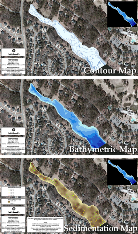
AS SEEN IN AssociationHelpNow, Issue 4, 2014: Written by Leigh Cesanek, AssociationHelpNow staff writer Dredging, the process of removing sediment and debris from lakes and ponds that builds up naturally over time, presents challenges to homeowners associations. Maintaining the environment of an association’s lake or pond provides for an overall better experience for residents and […]
When Accuracy Matters: GPS Bathymetric Lake Mapping
September 18th, 2014
Topics:
Lake Mapping and Bathymetry
Brought to you by our trusted partners at The Mapping NetworkWritten by Tyler VanMeeteren, Vice President. A lake or pond seems serene and effortless to maintain, but under the surface is a dynamic organism requiring expert knowledge to produce a perfect balance. To fully enjoy your waterbody, it is essential to know the facts for making […]
Pond Inspections and Bathymetric Studies
May 8th, 2014
Topics:
Lake Mapping and Bathymetry
Stormwater pond inspection and pond maintenance requirements vary from state to state and municipality to municipality. When a pond was constructed may also play a role in which stormwater regulations apply. The objective of these inspections, maintenance, and regulatory requirements are to ensure that stormwater ponds are functioning as designed, which is to collect pollutants, […]
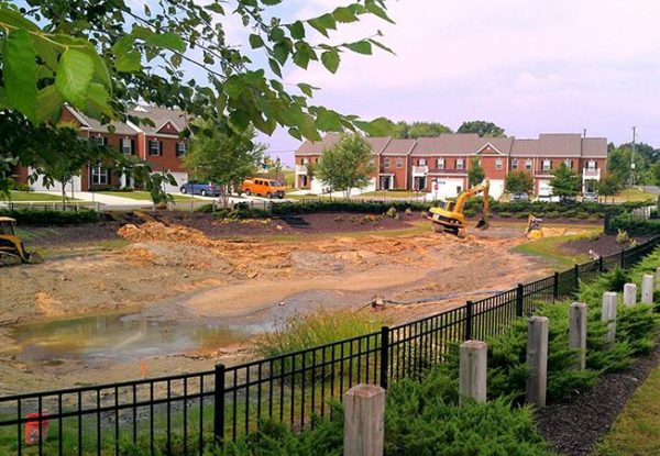
Pond Dredging: Planning For Your “Big Dig”
November 5th, 2013
If your community has a lake or pond, it may have crossed your mind that dredging will be needed at some point. Hopefully your community has had a professional reserve study performed which includes funds allocated to a future dredging project. If you have reviewed this line item, you may see that it is one […]

Sub Bottom Lake Mapping
January 19th, 2012
Topics:
Lake Mapping and Bathymetry
New! Sub-Bottom Sediment Profiling Mapping System True lake bottom profile can be seen with lake mapping technology As an exclusive Lake Mapping Partner of The Mapping Network, LLC., Solitude Lake Management is excited to share their latest addition of an automated sub-bottom sediment profile mapping system. This new technology is fully automated and does not […]
True Lake Bottom Profile Can Be Seen With Lake Mapping Technology
January 19th, 2012
Topics:
Lake Mapping and Bathymetry
New! Sub-Bottom Sediment Profiling Mapping System True lake bottom profile can be seen with lake mapping technology. Jan. 16, 2012 / As an exclusive Lake Mapping Partner of The Mapping Network, LLC., Solitude Lake Management is excited to share their latest addition of an automated sub-bottom sediment profile mapping system. This new technology is fully automated and does not […]
SOLitude Named The Mapping Network’s Partner of the Year Winner!
January 26th, 2011
Topics:
Lake Mapping and Bathymetry
The Mapping Network would like to congratulate SOLitude Lake Management® (formerly Virginia Lake Management) for winning the 2010 Partner of the Year for the second year in a row. Kevin Tucker, President of SOLitude Lake Management®, says “we are proud to have affiliated ourselves with such an incredibly talented group of aquatic professionals, and look forward […]
Why GPS Lake Mapping is Important
June 3rd, 2010
Topics:
Lake Mapping and Bathymetry
If you own lake property, you may wonder why it’s important to have the area mapped with GPS lake mapping technology. After all, it’s just water, and perhaps it’s deepest in the middle and shallow around the edges. Is it really necessary to know exactly every spot of depth in the lake or pond? If […]
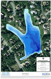
Engineers Select Local Bathymetric Lake Mapping Expert
May 5th, 2010
Topics:
Lake Mapping and Bathymetry
Source: The Mapping Network SOLitude Lake Management provided a bathymetric lake mapping for a lake in Virginia. Engineers recently performed a flood study on the dam and found the spillway insufficient. While preparing an engineering report to propose upgrade options the only bathymetric data available was hand collected in the 1950′s. As a local expert […]